
Product
-
Weather station
-
Road Weather Station
-
Photovoltaic Inspection
-
Atmospheric monitoring
-
Operating condition monitoring
Recommended article
- photovoltaic testers 400V/20A Range Meets the On-Site Testing Needs of Photovoltaic Modules
- Application of Low-Power Meteorological observation equipment in Unattended Field Monitoring
- How Portable Solar Cell Testers Rapidly Perform PV String I-V Curve Testing
- The price of meteorological monitoring systems varies from 3,900 to 39,800 yuan depending on the number of monitored elements
- Power Quality Measurement Makes Power Grid Harmonic Detection and Data Logging More Efficient
- High-Precision Meteorological observation equipment Aids Field Environmental Monitoring
Contact us
Shandong Fengtu IOT Technology Co., Ltd
Sales Manager:Ms. Emily Wang
Cel,Whatsapp,Wechat:+86 15898932201
Email:info@fengtutec.com
Add:No. 155 Optoelectronic Industry Accelerator, Gaoxin District, Weifang, Shandong, China
What kind of equipment is a fully automated imager?
Article source:Weather station time:2024-05-30 08:45:30 viewed:516times
Weather is closely connected with our daily life. In order to grasp the laws of the weather, human beings have always been relentless in their research and exploration. In ancient times, people relied on the observation of natural phenomena, combined with the changes of festive seasons, and developed numerous proverbs to predict the weather.
In modern times, we rely on meteorological observation stations all over the world and advanced observation tools, such as meteorological radar and satellites, to build up a sophisticated monitoring system, which greatly enhances our prediction ability and accuracy of weather changes.
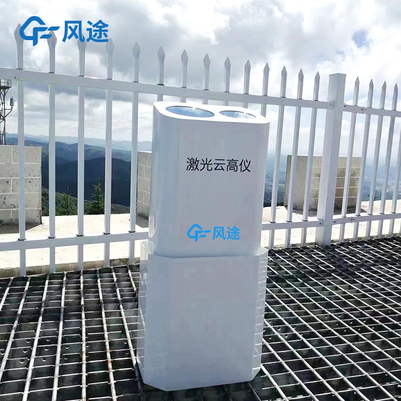
Cloud amount, cloud shape and cloud base height are key elements in meteorological observation. With the advancement of meteorological observation technology towards automation, a variety of automated cloud observation instruments have emerged. These cloud measurement devices can be mainly classified into types such as laser cloud altimeter, millimetre-wave cloud radar, imaging cloud meter and integrated cloud meter based on different measurement principles. Each type of equipment has its own unique advantages, and they can cooperate with each other to provide comprehensive data support for meteorological observations.
Fully automated imagers utilise the principle of metre scattering and are capable of covering a range of 12 kilometres with a wide range of functions that enable them to map the vertical distribution of aerosols, determine the base height of up to five layers of clouds, measure the thickness of cloud cover, assess vertical visibility and determine the height of the atmospheric boundary layer.
Its advantages are:
(1) The compact design and user-friendly interface of the device make it easy to operate and maintain. It has a wide measurement range and provides highly accurate results. Excellent anti-interference performance allows it to be adapted to a variety of application scenarios, including but not limited to fixed stations, aircraft, ships, vehicles, and portable handheld operations.
(2) Capable of capturing and recording detailed information about cloud cover changes over time in real time, providing cloud evolution data with high temporal and spatial resolution.
(3) Expertise in detecting thin clouds and low to medium height clouds.
This paper addresses:https://fengtuweather.com/industry/387.html
Related products
Related article
-
Dust Monitoring Equipment and PM2.5 Surveillance
2025-09-19 -
Dust: A Major Contributor to PM and the Solution of Detection
2024-12-20 -
Dust Monitoring and Control System in Open - pit Coal Mine
2024-11-12 -
Road Weather Station: Precision Monitoring, Intelligent Modeling, and Timely Warnings for Highway Safety
2025-02-26 -
Dust Monitoring Equipment with Spray Linkage: Intelligent System for Construction Site Dust Control
2025-07-07 -
Fengtu Small Automatic Weather Station: Integrated Monitoring for Timely Meteorological Insights
2025-07-10 -
Odor Monitoring System achieves 24-hour gas concentration monitoring through a multi-sensor array
2026-05-14 -
The Prominent Role of Fengtu's Road Weather Station in Transportation
2024-11-19