
Product
-
Weather station
-
Road Weather Station
-
Photovoltaic Inspection
-
Atmospheric monitoring
-
Operating condition monitoring
Recommended article
- photovoltaic testers 400V/20A Range Meets the On-Site Testing Needs of Photovoltaic Modules
- Application of Low-Power Meteorological observation equipment in Unattended Field Monitoring
- How Portable Solar Cell Testers Rapidly Perform PV String I-V Curve Testing
- The price of meteorological monitoring systems varies from 3,900 to 39,800 yuan depending on the number of monitored elements
- Power Quality Measurement Makes Power Grid Harmonic Detection and Data Logging More Efficient
- High-Precision Meteorological observation equipment Aids Field Environmental Monitoring
Contact us
Shandong Fengtu IOT Technology Co., Ltd
Sales Manager:Ms. Emily Wang
Cel,Whatsapp,Wechat:+86 15898932201
Email:info@fengtutec.com
Add:No. 155 Optoelectronic Industry Accelerator, Gaoxin District, Weifang, Shandong, China
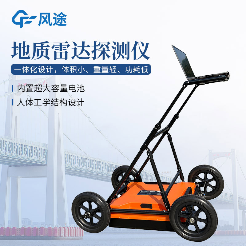
Advanced Geological Prediction in Tunnels with Ground Penetrating Radar
Article source:Weather station time:2025-03-17 13:38:05 viewed:467times
Advanced geological prediction is the core technical system for the safe construction of tunnels. According to the detection principle, its methods can be divided into three categories: geological analysis method, drilling method, and geophysical exploration method. Among them, Ground Penetrating Radar, as a typical representative of geophysical exploration methods, analyzes the underground structure by transmitting ultra - high - frequency electromagnetic waves in the megahertz (MHz) range (usually with a frequency range of 20 - 2000MHz) and receiving reflected signals. Its technical characteristics are as follows: Antennas in the low - frequency band (such as 20 - 200MHz) are relatively large in size, with strong electromagnetic wave penetration. The maximum detection depth can reach 30 meters, but the spatial resolution is relatively low. Antennas in the high - frequency band (such as 500 - 2000MHz) use compact pulsed antennas, with a resolution up to the centimeter - level, but the effective detection depth is only 3 - 5 meters.
In tunnel advanced geological prediction, the selection of antenna frequency needs to balance the dual requirements of detection depth and resolution accuracy. Taking a 100MHz shielded antenna as an example, its detection depth can reach 20 meters and it has a decimeter - level resolution, which is particularly suitable for identifying potential hazards such as karst caves and fault fracture zones within 10 - 15 meters in front of the tunnel face. The shielded design can effectively suppress the electromagnetic interference from the metal support structure in the tunnel and ensure data quality. In actual projects, technicians often use three - dimensional tomographic imaging technology to invert radar signals and combine with borehole verification (such as arranging horizontal drilling holes every 30 meters) to form a comprehensive prediction system of "geophysical exploration first, drilling verification second".
The advancement of this technology lies in: The integrity of rock masses can be judged by the intensity of time - domain reflected signals (the waveform of intact rock masses is uniform, and the fracture zone shows chaotic reflection characteristics). Combined with AI algorithms, it can automatically identify the boundaries of abnormal bodies. Compared with the traditional seismic wave method (TSP), it has a more refined shallow - layer analysis ability. In major projects such as pumped - storage power stations, Ground Penetrating Radar has become a key equipment for preventing geological disasters such as water inrush and rock burst.
This paper addresses:https://fengtuweather.com/industry/648.html
Related products
Related article
-
Dust Detector: A Smart Solution for Construction Site Dust Management
2025-04-23 -
Wireless garden environment weather monitoring station, scientific management of gardens
2024-06-05 -
Weather monitor Enables Low-Power, High-Precision Meteorological Monitoring in the Field
2026-05-21 -
Road Weather Station & Matching Environmental Monitoring Cloud Platform: Monitoring, Early Warning and Traffic Safety Guarantee
2025-08-25 -
What kind of instrument is a miniature weather station device?
2024-06-13 -
Important role of automatic weather stations
2024-03-06 -
Visibility Meter: Enhancing Traffic Safety
2024-09-19 -
The price of small integrated meteorological instruments ranges from 3900 to 39800 yuan
2026-06-15