

Product
-
Weather station
-
Road Weather Station
-
Photovoltaic Inspection
-
Atmospheric monitoring
-
Operating condition monitoring
Recommended article
- photovoltaic testers 400V/20A Range Meets the On-Site Testing Needs of Photovoltaic Modules
- Application of Low-Power Meteorological observation equipment in Unattended Field Monitoring
- How Portable Solar Cell Testers Rapidly Perform PV String I-V Curve Testing
- The price of meteorological monitoring systems varies from 3,900 to 39,800 yuan depending on the number of monitored elements
- Power Quality Measurement Makes Power Grid Harmonic Detection and Data Logging More Efficient
- High-Precision Meteorological observation equipment Aids Field Environmental Monitoring
Contact us
Shandong Fengtu IOT Technology Co., Ltd
Sales Manager:Ms. Emily Wang
Cel,Whatsapp,Wechat:+86 15898932201
Email:info@fengtutec.com
Add:No. 155 Optoelectronic Industry Accelerator, Gaoxin District, Weifang, Shandong, China
Ground Penetrating Radar: A Reliable Solution for Detecting Abandoned Mines and Ensuring Engineering Safety
Article source:Weather station time:2025-07-23 09:12:26 viewed:480times
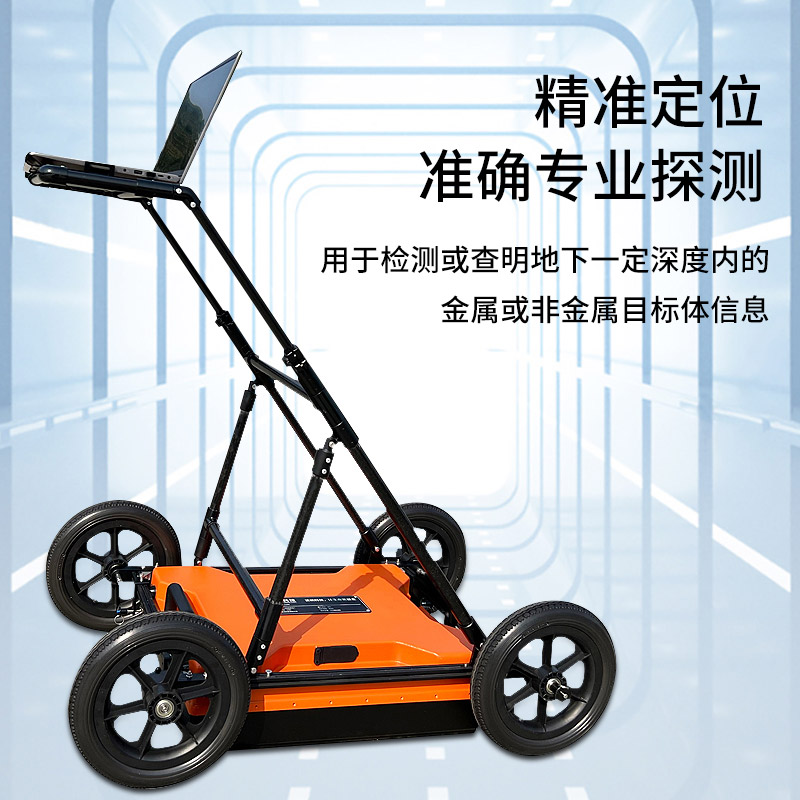
In areas with a long history of mineral resource development, a large number of unregistered or incompletely recorded abandoned mines are hidden underground, posing potential threats to engineering construction and geological safety. In mining areas severely affected by illegal and excessive mining, these hidden dangers are particularly prominent. Identifying the distribution range and burial depth of goaf roadways has become crucial to ensuring engineering safety, and Ground Penetrating Radar technology provides a reliable solution for this.
Ground Penetrating Radar, a broad-spectrum electromagnetic method developed in the 1970s, has become a major tool for shallow geophysical exploration due to its characteristics of being economical, non-destructive, fast, and intuitive. Its principle is similar to that of air-search radar, operating through a pair of antennas: the transmitting antenna emits high-frequency electromagnetic pulse waves, which are reflected when encountering underground physical property interfaces (such as mine boundaries). The receiving antenna captures the reflected signals and records the amplitude and travel time. Moving the antennas along the survey line can form a radar profile. When the wave velocity is known, the depth of the reflector can be inferred using the formula z = (vt)/2 (where z is the depth, v is the wave velocity, and t is the time).
Abandoned mines change the physical properties of underground media. The air, cavities, or fillings in the roadways differ from the surrounding rock mass in terms of dielectric constant and electrical conductivity. This electromagnetic difference not only causes the reflection of electromagnetic waves but also leads to attenuation and phase changes, providing a physical basis for identifying mines.
However, detection requires standardized operations: first, collect geological and mining history data to determine the possible depth and trend of the mines. During detection, the transmitting and receiving antennas move synchronously along the survey line, and the spacing is selected according to the target depth—the greater the depth, the larger the spacing. For data collection, the antennas must be kept stable, and the position of the survey line and topographic changes should be recorded. In complex areas, multi-line cross-detection is adopted to improve accuracy.
After processing the original data, the position and shape of the mine can be accurately determined based on the characteristics of the reflected wave event axes, energy attenuation, and phase changes in the radar profile.
This paper addresses:https://fengtuweather.com/industry/752.html
Related products
Related article
-
Five-in-One Weather Station for 24-Hour Continuous Monitoring of Outdoor Meteorological Parameters
2026-03-05 -
10 metre manual common lightning rod is convenient and easy to use
2024-04-25 -
FT-CZ5S Vehicle-Mount Weather Station: Ideal for Off-Road Vehicles with All-Weather Monitoring Capabilities
2025-05-22 -
Controlling Erosion & Dust: FT-QX9 Meteorological System for Hydropower Spoil Management
2025-06-23 -
ntroduction to the Forest Fire Monitoring System
2024-05-23 -
Introduction to forest security monitoring systems
2024-04-12 -
Functions of automatic meteorological monitoring station for field microclimate
2024-07-25 -
Shandong Fengtu An Integrated Manufacturer of Weather Stations with a Complete Production Chain
2026-03-25