
Product
-
Weather station
-
Road Weather Station
-
Photovoltaic Inspection
-
Atmospheric monitoring
-
Operating condition monitoring
Recommended article
- The FT series of meteorological observation equipment covers various types, including portable, explosion-proof, ultrasonic, and hydrological models
- Handheld IV Testers Improve On-Site Testing Efficiency for Photovoltaic Power Plants
- The price of small integrated meteorological instruments ranges from 3900 to 39800 yuan
- I-V Curve Tracer can measure up to 400V and 20A of current
- The miniature weather station equipment outputs twelve monitoring data points simultaneously via a digital interface
- Atmospheric electric field meters provide early warnings of thunderstorm activity by monitoring changes in the ground electric field
Contact us
Shandong Fengtu IOT Technology Co., Ltd
Sales Manager:Ms. Emily Wang
Cel,Whatsapp,Wechat:+86 15898932201
Email:info@fengtutec.com
Add:No. 155 Optoelectronic Industry Accelerator, Gaoxin District, Weifang, Shandong, China
Forestry Weather Station Determining Fire Risk Levels via Meteorological Factor Monitoring
Article source:Weather station time:2026-03-23 11:22:23 viewed:317times
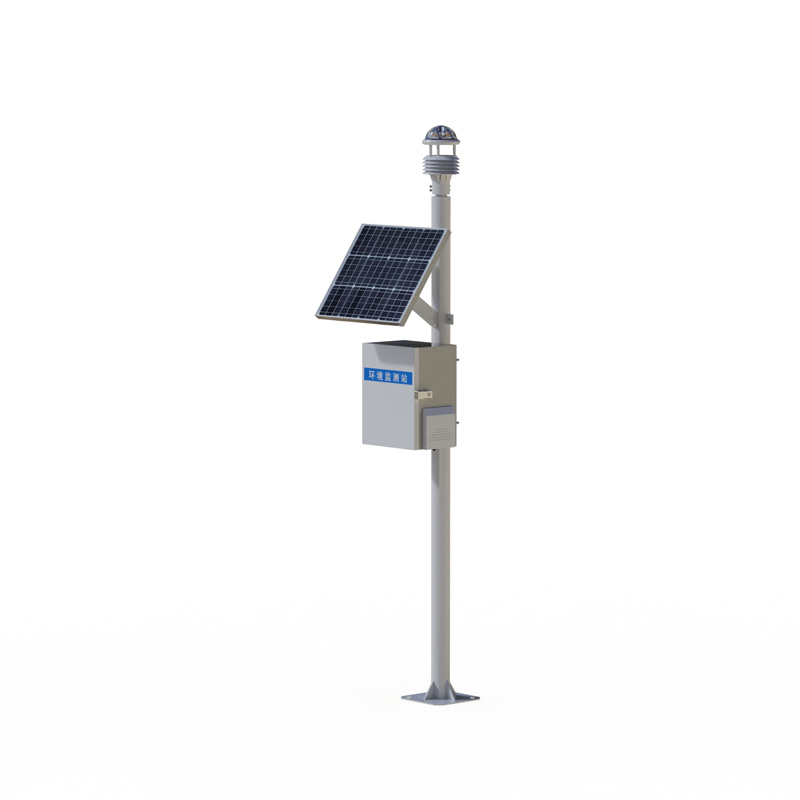
Forestry Weather Station consists of a forest fire prevention meteorological station and an integrated environmental monitoring cloud platform. By continuously monitoring meteorological factors—such as wind speed, wind direction, temperature, relative humidity, and solar radiation—it provides essential data support for determining fire risk levels, thereby integrating both fire monitoring and early warning capabilities into a single system.
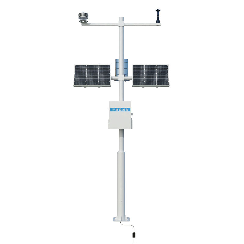
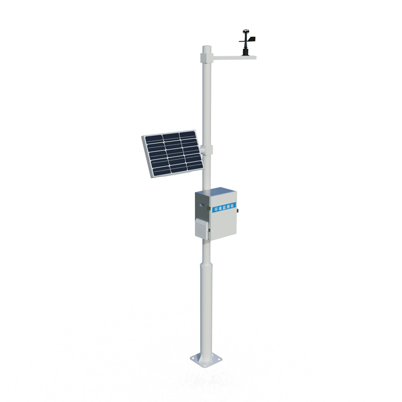
Forestry Weather Station is a specialized meteorological observation system designed specifically for forest fire prevention and emergency response. The system comprises two main components: the forest fire prevention meteorological station and the integrated environmental monitoring cloud platform. Deployed in areas prone to forest fires, it provides real-time data support for fire prevention efforts by continuously monitoring key meteorological factors.
Forestry Weather Station serves as the front-end data acquisition unit, installed either at ground level within the forest area or atop lookout towers. The sensor unit includes sensors for wind speed and direction, temperature and humidity, and solar radiation, which collectively measure four key meteorological parameters: wind speed, wind direction, air temperature, relative humidity, and solar radiation. A data logger reads the sensor values at a preset frequency, performs preliminary processing, and transmits the processed data to the cloud platform via a wireless communication module. The power supply system utilizes solar panels paired with backup batteries, ensuring the device operates continuously even in forest areas where external power sources are unavailable.
Wind speed and direction data are used to determine the direction and rate of fire spread; temperature data reflects the dryness of combustible materials on the forest floor; relative humidity directly influences the moisture content of these combustible materials; and solar radiation characterizes the thermal conditions of the ground surface. These four meteorological factors are closely correlated with forest fire risk levels; by continuously monitoring and capturing the real-time fluctuations of these parameters, the system provides robust, data-driven support for accurately determining the current fire risk level.
The integrated environmental monitoring cloud platform is responsible for data reception, storage, analysis, and early warning dissemination. The platform receives real-time data uploaded from each meteorological station and stores it in a database as a time series. An embedded fire risk calculation model within the system automatically computes the current fire risk level based on the wind speed, temperature, humidity, and radiation data; whenever the calculated risk level reaches a predefined threshold, the platform automatically issues an early warning alert.
In the context of forest fire prevention, the continuous monitoring data provided by Forestry Weather Station enables management authorities to effectively track and understand the evolving meteorological conditions within the forest areas under their jurisdiction. When a combination of meteorological factors reaches high-risk thresholds, management authorities can proactively intensify patrols and restrict potential ignition sources from entering the area. In the event of a fire, real-time monitoring data serves to guide firefighting operations; specifically, data on wind speed and direction aids in predicting the direction of fire spread, thereby facilitating the strategic deployment of firefighting resources. By effectively integrating meteorological monitoring with fire management, this system provides a quantitative basis for decision-making in forest fire prevention efforts.
This paper addresses:https://fengtuweather.com/company/898.html
Related products
Related article
-
Substation micrometeorological environment monitoring
2024-06-18 -
Road Weather Station: Ensuring Safe Transportation with Precise Monitoring
2024-09-14 -
Combatting Dust: The Role of Dust Monitoring Equipment in Protecting Air Quality
2025-01-02 -
Building a Meteorological Station: Steps and Considerations
2024-10-09 -
Meteorological station Solar-Powered and Modularly Designed for Long-Term Field Monitoring
2026-04-21 -
Meteorological monitoring system meteorological monitors
2024-06-21 -
Explore Fengtu's Weather Instruments: From Automatic Stations to Handheld Meters
2025-02-06 -
Meteorology in Motion: Vehicle-Mounted Stations for Precision Data Collection
2025-04-29