
Product
-
Weather station
-
Road Weather Station
-
Photovoltaic Inspection
-
Atmospheric monitoring
-
Operating condition monitoring
Recommended article
- photovoltaic testers 400V/20A Range Meets the On-Site Testing Needs of Photovoltaic Modules
- Application of Low-Power Meteorological observation equipment in Unattended Field Monitoring
- How Portable Solar Cell Testers Rapidly Perform PV String I-V Curve Testing
- The price of meteorological monitoring systems varies from 3,900 to 39,800 yuan depending on the number of monitored elements
- Power Quality Measurement Makes Power Grid Harmonic Detection and Data Logging More Efficient
- High-Precision Meteorological observation equipment Aids Field Environmental Monitoring
Contact us
Shandong Fengtu IOT Technology Co., Ltd
Sales Manager:Ms. Emily Wang
Cel,Whatsapp,Wechat:+86 15898932201
Email:info@fengtutec.com
Add:No. 155 Optoelectronic Industry Accelerator, Gaoxin District, Weifang, Shandong, China
Functions of the Integrated Cloud Gauge application
Article source:Weather station time:2024-03-21 08:56:01 viewed:505times
The main functions of the Integrated Cloud Gauge application software are:
Communicate with the integrated cloud gauge to obtain detection data and equipment status, and send commands.
Display and save the cloud gauge's detection results.
View historical data and images for a specific time period.
The software interface is divided into two parts: "real-time measurement" and "historical data". The "real-time measurement" interface includes four display areas: image, text, status and trend.
The "Text Area" displays the real-time sky status, centre cloud height and cloud amount data.
The "Status Area" displays the connection and working status of the device, red is abnormal and green is normal.
The "Trend Area" displays real-time changes in cloud amount and centre cloud height for the last hour.
The "Historical Data" screen displays historical images, text results, status, extended cloud altimeter results and 24-hour cloud trends.
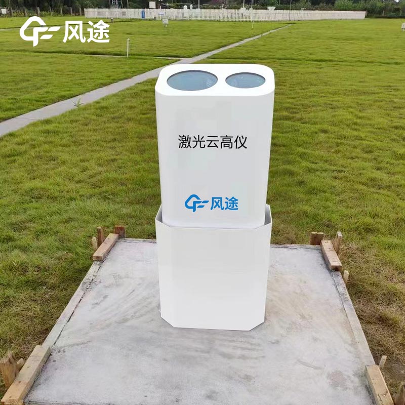
Common cloud measurement devices include laser cloud gauges, millimetre wave cloud radar, imaging cloud gauges and integrated cloud gauges. They observe cloud properties through different technical principles, each with its own advantages that complement each other.
The integrated cloud altimeter is based on the metre scattering principle. By measuring the scattering signals of infrared light beams in the atmosphere, it determines the cloud conditions and calculates the height and thickness of the cloud bottom. It also estimates aerosol extinction coefficient, atmospheric boundary layer height and vertical visibility. Through continuous observation, the laser cloud altimeter can also help us estimate the cloud amount.
Features:
(1) Compact and easy-to-operate equipment, simple maintenance, wide measurement range, strong anti-interference ability, suitable for a variety of application scenarios.
(2) Provide high temporal and spatial resolution cloud evolution information.
(3) Capable of capturing thin and low-middle clouds.
(4) All-weather operation, not affected by bad weather.
(5) Friendly operation interface, simple maintenance, no consumable devices.
(6) Dual lens design, strong self-test function, high sampling accuracy.
(7) High sensitivity optical parts, day and night can be measured.
This paper addresses:https://fengtuweather.com/industry/253.html
Related products
Related article
-
Automated Weather Station Installation Costs Range from ¥3,900 to ¥9,800
2026-05-06 -
Multifunctional weather station is a high-precision digital monitoring device for six key meteorological elements in real time
2025-12-19 -
How Forestry Weather Stations Bolster Forest Fire Prevention Efforts
2025-01-15 -
FT - CZ5SVehicle - Mount Weather Station: Uniting Surveillance and Mobility for Environmental Monitoring
2025-04-15 -
Geological Disaster Monitoring Systems by Fengtu Technology
2025-09-08 -
Vehicle-Mounted Small Automatic Weather Station: Mobile Precision for Dynamic Meteorological Monitoring
2025-07-04 -
Ground Penetrating Radar for Detecting Roadway Surrounding Rock Loose Zone
2025-07-29 -
The Mobile Edge in Meteorology: Vehicle - Mount Weather Stations
2025-04-07