
Product
-
Weather station
-
Road Weather Station
-
Photovoltaic Inspection
-
Atmospheric monitoring
-
Operating condition monitoring
Recommended article
- photovoltaic testers 400V/20A Range Meets the On-Site Testing Needs of Photovoltaic Modules
- Application of Low-Power Meteorological observation equipment in Unattended Field Monitoring
- How Portable Solar Cell Testers Rapidly Perform PV String I-V Curve Testing
- The price of meteorological monitoring systems varies from 3,900 to 39,800 yuan depending on the number of monitored elements
- Power Quality Measurement Makes Power Grid Harmonic Detection and Data Logging More Efficient
- High-Precision Meteorological observation equipment Aids Field Environmental Monitoring
Contact us
Shandong Fengtu IOT Technology Co., Ltd
Sales Manager:Ms. Emily Wang
Cel,Whatsapp,Wechat:+86 15898932201
Email:info@fengtutec.com
Add:No. 155 Optoelectronic Industry Accelerator, Gaoxin District, Weifang, Shandong, China
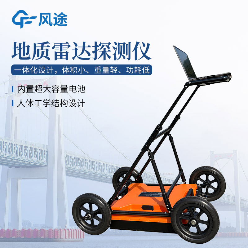
Portable Ground Penetrating Radar: A Comprehensive Guide to Subsurface Imaging Technology
Article source:Weather station time:2025-09-28 09:36:25 viewed:530times
The objective need for non-destructive and efficient detection of underground structures has driven the development of shallow geophysical exploration technology. In fields such as engineering investigation, infrastructure construction, and environmental surveys, there is a need for technical means that can quickly obtain continuous subsurface profile information to compensate for the high cost, low efficiency, and point-only information limitations of traditional drilling methods. Ground penetrating radar technology based on electromagnetic wave theory, with its high-resolution characteristics in shallow layers, has become one of the key technologies to meet this demand.
Portable Ground Penetrating Radar is a high-tech instrument that uses high-frequency electromagnetic waves (typically 10 MHz to 2.5 GHz) to detect subsurface medium distribution characteristics. It analyzes the structure, properties, and spatial location of underground objects by transmitting electromagnetic waves into the ground and receiving reflected signals from different subsurface medium interfaces (such as soil and rock, concrete and steel reinforcement, cavities and solid soil).
Just like bats use ultrasonic echolocation, ground penetrating radar "shouts" into the ground (transmits electromagnetic waves) and then "listens" to the echoes (receives reflected waves). By analyzing the strength and time difference of these echoes, it creates a "map" of the subsurface.
Advantages:
Non-destructive testing, causing no damage to surface or underground objects.
High efficiency, with fast data acquisition speed, enabling rapid coverage of large areas.
High resolution, far superior to other geophysical methods in shallow layer detection.
Intuitive results, with radar profile images that are easy to understand and interpret.
Portable equipment, suitable for operation in various complex environments.
This paper addresses:https://fengtuweather.com/industry/803.html
Related products
Related article
-
Radar speed gun Supports Real-Time Printing of Speeding Data
2026-06-22 -
Meteorological Monitoring System: Comprehensive Functions and Modern Applications
2025-08-13 -
Harnessing Dust Detectors: Precision Tools for Pollution Prevention
2025-04-25 -
How do you measure negative oxygen ion concentration? Real-time this portable instrument
2024-04-07 -
There are two types of handheld meteorological instruments
2024-01-29 -
Small-scale six-element automatic weather station enables continuous all-weather monitoring of outdoor meteorological parameters
2026-07-03 -
Integrated PV inverter tester optimises power generation efficiency
2024-06-04 -
Meteorological Science Popularization in Schools: Campus Weather Station Introduction
2024-10-21